 |
Where is Mount Sinai?:The story of the Exodus Posted: 19th August, 2011 |
 |
The full version is broken into a number of parts due to its length (over 24,000 words). It covers each point in more detail in addition to dealing with a number of matters not mentioned in the short version. |
|
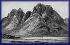
The holy mountain is shrouded in mystery, its location seemingly unknowable. Perhaps that is what makes it holy. Louis Feldman, Josephus's View of the Amalekites, Bulletin for Biblical Research, 12.2, 161-186 PILGRIMS FLOCK BY THEIR THOUSANDS every year to the traditionally-accepted location of Mount Sinai in the south of the Sinai Peninsula where Moses is reputed to have encountered the burning bush and, forty years later, returned with two million or so of his countrymen after escaping from Egypt. Are millions of tourists being taken for a ride by their hosts and guides? Traditionalists argue over exactly which body of water the Israelites crossed, but they all place it somewhere along Egypt's eastern border region. They argue about the specific peak that was Sinai — at least a dozen have been suggested — but they all place it in what is today called the Sinai Peninsula. However, those who critically and open-mindedly compare traditional ideas about the Exodus, the sea crossing, and the site of the "mountain of God" with the biblical record, almost unanimously come away with a radically revised opinion. Most students who buck the traditional view agree on two fundamental points: first, that the crossing occurred somewhere in the depths of the Gulf of Aqaba and, second, that Mount Sinai therefore must be found somewhere in north-western Saudi Arabia. This author agrees. At stake is the glory of God and the credibility of the Bible. Few people are willing to credit such power to God that He could create walls of water towering thousands of feet high. That's where they are wrong. The identity of the Red SeaFew topics betray more clearly the anti-supernatural prejudice of many writers and the subsequent weasel logic they bring to bear on the question of which body of water Moses was talking about in Exodus 15:4: Pharaoh's chariots and his army He has cast into the sea; his chosen captains also are drowned in the Red Sea. We can identify the "real" Red Sea with considerable confidence if we accept the biblical data. True, the Hebrew term, Yam Suf, does not literally mean "Red Sea". "Yam" is the normal word for "sea", while "suf " appears to have a number of possible meanings. However - and this is a critical point - the biblical data do make plain that the term definitely can refer to what we today know as the Gulf of Aqaba. One verse alone suggests that it may also refer to what we call the Gulf of Suez or to some other major body of water east of the Egyptian delta. Other facts, however, make the likelihood of a crossing over the Gulf of Suez or any other nearby body of water extremely remote, leaving the Gulf of Aqaba as the sole contender. 1 Kings 9:26 proves that Yam Suf refers to the Gulf of Aqaba: King Solomon also built a fleet of ships at Ezion Geber, which is near Elath on the shore of the Red Sea [Yam Suf], in the land of Edom. The identification of Yam Suf with the Gulf of Aqaba in this verse is unambigous. Other verses that verify the equation between Yam Suf and the Gulf of Aqaba include Exodus 23:31, Numbers 21:4, 1 Kings 22:48, and Jeremiah 49:21. Based on this vital evidence, one can conclude that the corridor of deliverance most likely crossed the Gulf of Aqaba. Yes, it's that simple. Where is Mount Sinai?Here is vital information for revealing the general whereabouts of Mount Sinai, the place where God made the punitive old covenant with Israel after they had fled from Egypt. God said to Moses while he was at Mount Sinai tending sheep, "Come now, therefore, and I will send you to Pharaoh that you may bring My people, the children of Israel, out of Egypt." But Moses said to God, 'Who am I that I should go to Pharaoh, and that I should bring the children of Israel out of Egypt?' So He said, "I will certainly be with you. And this shall be a sign to you that I have sent you: When you have brought the people out of Egypt, you shall serve God on this mountain" (Ex. 3:10-12). God promised Moses that He would bring the entire house of Israel to this same mountain to worship Him. Where was this mountain? Although no geographical coordinates are given in this account the general locality is made abundantly clear; it was in Midian! When he was in fear of his life at the hand of Pharaoh, Moses fled to the land of Midian (Ex. 2:15) where he married the daughter of the Midianite priest, Jethro, and lived for forty years. Towards the end of the forty years he "… led the flock to the back of the desert, and came to Horeb, the mountain of God" (Ex. 3:1) where the burning bush episode occurred. The rest, as they say, is history.
Where is Midian?, you rightly ask. It was on the eastern side of the Gulf of Aqaba, in what is today the Hejaz region of Saudi Arabia. We propose that Mount Sinai is to be located towards the southern end of the land of Midian. Can we narrow it down further? Don't dilly dally on the wayExodus buffs often ignore a piece of helpful evidence in the search for Mount Sinai - Elijah's pilgrimage to the holy mountain. When Wicked Queen Jezebel issued a death warrant against him, Elijah, depressed and discouraged, fled to Beersheba where he fell into a deep sleep. Upon awaking, he found a hearty meal waiting for him. An angel told him he was about to go on a long journey, upon which Elijah. . arose, and ate and drank; and he went in the strength of that food forty days and forty nights as far as Horeb, the mountain of God (1 Kin. 19:8). Assuming that Elijah's strength was miraculously sustained for the entire period, we can deduce that Mount Sinai was a considerable distance away. (Such an assumption is surely a safe one when you consider the alternative. Without a miracle, Elijah would have died!) If he walked 20 miles per day he would have travelled 680 miles. At ten miles per day - a near insult to his manhood - 340 miles. A problem immediately arises; at even the insult pace, he could have walked way, way past the very southern tip of the Sinai Peninsula (235 miles) and considerably further than any of the proposed "true Sinais" if he took the shortest route. A simple solution is to assume he walked from Beersheba to Jericho, the point at which the Israelites' wanderings came to an end, and then made pilgrimage by retracing the path taken by the Israelites to that point from Mount Sinai. The point is, the Elijah pilgrimage provides strong support for the most distant candidate for Mt Sinai that fits all the other important criteria. "Our Sinai", located in north-west Saudi Arabia, would have taken him on a 490 mile pilgrimage, an average of 14.5 miles per day. The minimum distance we may expect Elijah to have walked must be set against the maximum distance the Israelites could have travelled after crossing the sea. We can deduce that the crossing occurred about the 22nd day after leaving Egypt. The total time taken to get from Rameses to Mount Sinai is revealed in Exodus 19:1: In the third month after the children of Israel had gone out of the land of Egypt, on the same day, they came to the Wilderness of Sinai. The phrase "on the same day", meaning literally "in that/this day", is an idiom meaning "the first day of the month". From the 15th Nissan, when they departed Egypt, to the first day of Sivan is a total of 45 days, meaning they had another 22 to 23 days to walk from the far side of the Red Sea to Mount Sinai. Taking time out for Sabbath rest, they had roughly 18-19 days to get to Mount Sinai. If they maintained their earlier pace and walked twenty miles per day they would have covered 360 miles. But after crossing the sea, everything changed. The pressure was now completely off as flight was no longer necessary, so the pace of progress dropped dramatically. The average daily walk undoubtedly fell below ten miles per day. We can estimate they traveled approximately 100 to 150 miles.
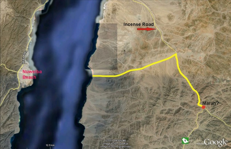
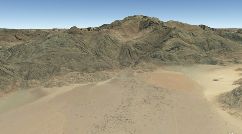
Logic suggests that the quest for the true Sinai should concentrate on an area between 100 and 150 miles south of the crossing site. Searching for a majestic mountain peak that meets this criterion among the mountains of the coastal chain running roughly parallel to the Red Sea leads to an unnamed peak1 situated about 125 miles south of the beach landing. Its coordinates are 27 51 35 35 44 33. Copy and paste them into the search box in Google Earth and you will see what is probably the true Mount Sinai for the first time in your life. In order to distinguish this peak from all others we will refer to it as Har Kodesh.2 The Exodus route in the roughThe above two pieces of critical information go hand in glove to establish with near certainty a clear general picture. (We can eliminate the Gulf of Suez and all the borderland lakes, marshes, and lagoons from the list of crossing candidates on the simple grounds that they do not match a plain reading of the biblical account.) When the Israelites left Egypt they fled generally south-east across the centre of the Sinai Peninsula at breakneck speed along the well-travelled King's Highway. After an unexpected command to change direction, they ended up travelling along a wadi that led them to the Gulf of Aqaba at a point about a third of the way down its coast. Here they became trapped between the watery deeps on the east and Pharaoh's army and mountains on the west. After crossing the Red Sea, they journeyed eastward for a few days in mountainous wilderness before reaching the Wadi l-Abyad, a wide wadi slashing from the north to the south in Midian and forming a leg of the ancient incense route. Here they turned south and proceeded to their destination - Mount Sinai. This map provides a no-frills overview of the route from Egypt to Har Kodesh. The books of Exodus and Numbers provide a considerable amount of detail that can help us narrow down the field with respect to both the crossing point and the location of Mt Sinai. The crossing pointExodus 13:17 helps eliminate a crossing point anywhere near Egypt: Then it came to pass, when Pharaoh had let the people go, that God did not lead them by way of the land of the Philistines, although that was near; for God said, "Lest perhaps the people change their minds when they see war, and return to Egypt." God knew that, in spite of their insatiable hunger for freedom from servitude, the fear of danger, and the hunger for the familiar could lead them right back to where they came from. Exodus 17:1-4 recounts how, after crossing the Red Sea, the Israelites became so dissatisfied with privation and discomfort they were ready to stone Moses. Stop and think. If they had crossed any body of water close to Egypt they would have been barely a stone's throw from home. Turning back would have been easy. Yet they never contemplated it. One must conclude they were a long way from home, a fact that fits a Gulf of Aqaba crossing into Midian. Another critical piece of evidence is found in Exodus 13:20 -14:4: So they took their journey from Succoth and camped in Etham at the edge of the wilderness . Now the Lord spoke to Moses, saying: "Speak to the children of Israel, that they turn and camp before Pi Hahiroth, between Migdol and the sea, opposite Baal Zephon; you shall camp before it by the sea. For Pharaoh will say of the children of Israel, 'They are bewildered by the land; the wilderness has closed them in.' Then I will harden Pharaoh's heart, so that he will pursue them; and I will gain honor over Pharaoh and over all his army, that the Egyptians may know that I am the Lord."
This passage tells us that the Israelites were heading for the Promised Land across the Sinai Peninsula up till the point they arrived at Etham. At Etham they were instructed to "turn" and go to Pi Hahiroth on the Red Sea. It also reveals that as a result of the turn they would become "bewildered" by the terrain and find themselves hemmed in. An examination on Google Earth of all the possible routes to any of the traditional crossing sites close to Egypt fails to find a route that matches this account. Contrariwise, these verses make perfect sense if the Israelites were close to the easternmost boundary of the Sinai Peninsula, close to the northern tip of the Gulf of Aqaba. A sharp turn towards the south some miles west of modern Eilat makes wonderful sense. The Israelites would have ended up being forced into the Wadi Watir along which they would have wended their way to a large beach - Nuweiba Beach - on the west side of the Gulf of Aqaba. At around ten square miles in area, this beach appears to have been prepared for this year, this month, this day, this hour. Here, with rugged mountains locking them in on the west and the deep sea to the east, the Israelites would have watched in horror as the Egyptian army galloped into view along the Wadi Watir towards them. Here they had no way of escape. Not until, that is, God split the mighty Gulf of Aqaba and drove a dry corridor right through its midst. Safety lay in the land of Midian, ten miles away. The water here drops to a depth of nearly 2500 feet. Imagine yourself walking through its midst with a wall of water towering that far above you on either side. Everybody knows what happened next, so let's skip the watery crossing and join the Israelites on the beach in Midian. The route from crossing point to Mount SinaiThe most telling piece of data for reconstructing the route taken from the Red Sea can be found in Numbers 33:10. Following a week or so of journeying, They moved from Elim and camped by the Red Sea. This one fact scuttles the Gulf-of-Suez-crossing idea. Google Earth shows that, apart from the stretch between Gharandal and Abu Zenima, they would have camped by the seaside night after night en route to the traditional Mount Sinai at Jebel Musa. Numbers 33 is clear that the Israelites chanced upon the Red Sea again after journeying for some days away from the Red Sea. How did that happen? After spending a day or two on the beach, Moses brought Israel from the Red Sea; then they went out into the Wilderness of Shur. And they went three days in the wilderness and found no water (Ex. 15:22).3 One direction alone from the beach head4 took them "from" the Red Sea - directly east. After climbing gently for fifteen miles from sea level to an elevation of about 3000 feet, they would have come upon the ancient incense road slicing north-south through the middle of Midian following the wide, dry Wadi l-Abyad. (Modern Highway 5 undoubtedly follows exactly the same route for much of its length. Make sure "Roads" are checked in Google Earth to find it.) When the Israelites reached this road they could have turned left (north) or right (south). Which way did they go? For a number of reasons, we can reject the idea that they headed north. They must have turned south down the incense road, putting them on a collision course with the Red Sea proper. No other reconstruction fits the biblical record so perfectly and so naturally.
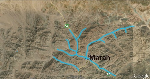
The discovery of water, albeit undrinkable, at Marah after three days of passing through waterless terrain (Ex. 15:23) makes perfect sense. For some distance south from the beach landing, the land slopes steadily towards the sea from higher elevations inland. Runoff would drain away quickly and run straight across the incense road in its dash to the sea. Finding water here would be most unlikely except immediately after rain. However, when you reach a place while travelling south called Ash Sharaf,5 the topography changes. From here on, higher elevations flank both sides of the road, meaning that runoff flows onto it from both east and west and then turns south to follow the path of the descending road. Ash Sharaf is the first point where water is likely to pool after rain. Could it be Marah?
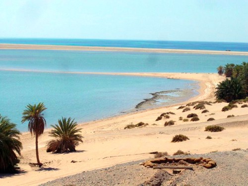
The next place listed as a camp site is Elim, where the happy hikers found twelve wells and seventy shady palm trees. One has fair reason to identify it with modern Al Bad.6 Next stop on the incense road - sun, sand, and swimming at the Red Sea.7 At about 27 miles from Al Bad, it could have been reached in a couple of days with ease. Your own imagination, inspired by a couple of pictures, can fill in the details of a day or two by the Red Sea. The critically important point to be made is that the route being proposed here makes the most sense of a return to the Red Sea a week or so after departing from it.
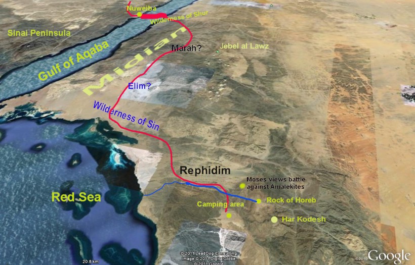
Numbers 33 completes the list of campsites between the Red Sea and Mount Sinai: They moved from the Red Sea and camped in the Wilderness of Sin. They journeyed from the Wilderness of Sin and camped at Dophkah. They departed from Dophkah and camped at Alush. They moved from Alush and camped at Rephidim, where there was no water for the people to drink. They departed from Rephidim and camped in the Wilderness of Sinai (11-15). The precise location of the Wilderness of Sin, Dophkah and Alush is a matter of conjecture as we are given no specifics at all. Whether the Israelites headed directly east from the Red Sea camp and then south, or whether they continued on down the incense road until the time came to branch off is impossible to say. Instead, let us turn to the question of locating Mount Sinai. After that we will consider the location of Rephidim, the last stop before reaching Mount Sinai. Let us here include a picture that combines all the information presented both above and below to provide an overview of the route from the beach to Har Kodesh together with places of major interest to us. (Text colors vary purely for purposes of providing contrast against background.)
Mount SinaiIn a nutshell, we are looking for a mountain located about five days walking distance from the Red Sea encampment - say, roughly 30 to 60 miles. In that vicinity we find the unnamed peak mentioned earlier - our Har Kodesh - that matches the scriptural details concerning Mount Sinai. By examining these details we can eliminate all the possibilities but this one peak. Not to mention it has grand aesthetic appeal, is set in a beautiful landscape, and is located an easy fifteen mile amble from the delightful Red Sea, the perfect holiday destination. No wonder the Israelites didn't grumble the whole time they were there. Properties that the true Mount Sinai must have are, • a suitable camping area at its base; These features are not optional extras but absolute prerequisites for Mount Sinai. Room for a ponyExodus 19:16-20 shows that the Israelites camped on a plain at the foot of the mount. If you Google Earth the coordinates given above for Har Kodesh, an ideal camp ground jumps right up at you8 - big enough to provide "room for a pony". It would appear to be eight to ten square miles in area when you add in all the adjoining wadis. That's close to six thousand acres, ideal for a sprawling tent city. Overflow could spill over into the low, gentle hills (possibly vegetated sand dunes) lying to the west and north. None of the traditional sites for Mount Sinai has anything to compare. Its sandy substrate would make for happy campers. Streams in the desertEveryone knows of the famous golden calf incident that occurred at Mount Sinai. Moses later recounted that, Then I took your sin, the calf which you had made, and burned it with fire and crushed it and ground it very small, until it was as fine as dust; and I threw its dust into the brook that descended from the mountain (Deut. 9:21). That the brook actually had water in it at the time is made clear from the parallel account in Exodus 32:20. The true Sinai must have evidence of a brook flowing through the campground. Har Kodesh scores a strong tick on this point, as seen in this picture snapped from 5000 feet elevation. In all likelihood Moses followed the course of this stream when he climbed the mountain to meet God.
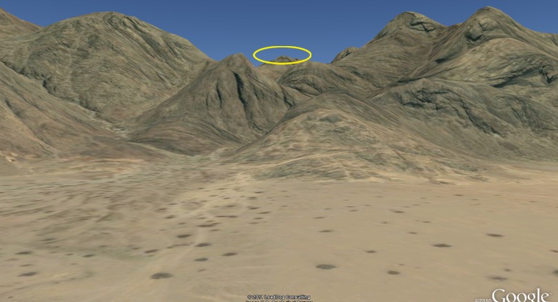
The spots on the ground represent large Acacia raddiana trees. Their arrangement indicates a seasonal flow of water across the plain. This stream likely flowed the entire time the Israelites camped there. They had to have water from somewhere, and we have no record of them complaining about the lack of it. Room with a viewA critical property of the true Mount Sinai is that, as noted above, it must be visible from at least a significant portion of the campground: And Moses brought the people out of the camp to meet with God, and they stood at the foot of the mountain. The peak of Har Kodesh is visible from our camp ground. The further back one stands from the foot of the mountain the better the view. This ability to see the summit from the camping area is totally lacking at traditional Jebel Musa.
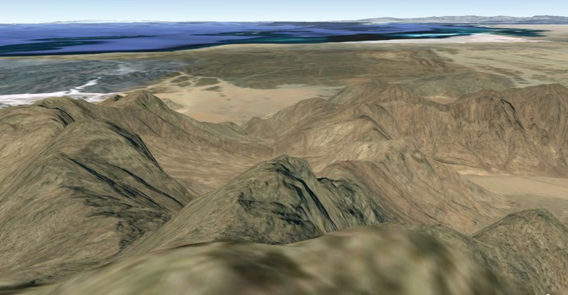
This picture is what you would see from about one mile away from the base. You would get a better view further back. Let's turn the tables now and take a Moses'-eye-view of the campground and surrounding scenery.
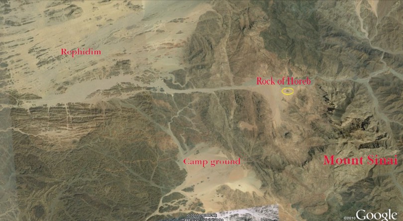
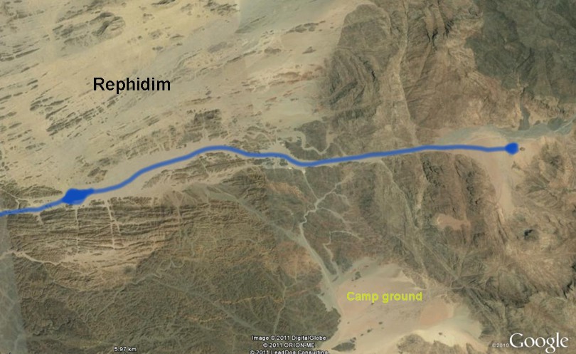
Isn't that spectacular? The Red Sea is plainly visible, and to the top right of the picture you can see a portion of Rephidim. The rock of HorebAnother intriguing feature of the true Sinai is brought out in Exodus 17:1-6: Then all the congregation of the children of Israel set out on their journey from the Wilderness of Sin, according to the commandment of the Lord , and camped in Rephidim; but there was no water for the people to drink. And the people thirsted there for water, and the people complained against Moses, and said, "Why is it you have brought us up out of Egypt, to kill us and our children and our livestock with thirst?" So Moses cried out to the Lord , saying, "What shall I do with this people? They are almost ready to stone me!" And the Lord said to Moses, "Go on before the people, and take with you some of the elders of Israel. Also take in your hand your rod with which you struck the river, and go. Behold, I will stand before you there on the rock in Horeb; and you shall strike the rock, and water will come out of it, that the people may drink." This passage presents a puzzle which is readily solved with the help of Google Earth. Note: God instructs Moses to go from Rephidim to Horeb (Sinai) to a particular rock and to strike it. Upon doing so, water would start to flow from the rock at Horeb and solve the problem of lack of water in Rephidim! Note this amazing comment from Stone's Chumash: . since the miracle would take place in Horeb, which was some distance from Rephidim, it was necessary to take the elders to see what was about to happen. Once the rock was split, the water flowed to the nation in Rephidim (Scherman, p. 390). When this rock at Mount Sinai gushed like a geyser the water didn't flow into the Sinai campsite but into the Rephidim campsite. This picture shows the overall layout.
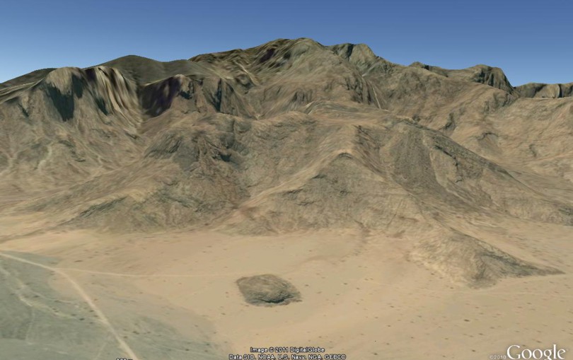
Note the location of the campsite at Rephidim in relation to the rock at Horeb.9 The rock is huge, being roughly 250 yards long and 30 feet high. This picture explains why this rock is linked with Mount Sinai.
As you can see, it's virtually at the foot of Har Kodesh. Elevation data show that the raging torrent of water that poured from this rock flowed straight along the natural wadi for ten miles until reaching the Rephidim campsite.
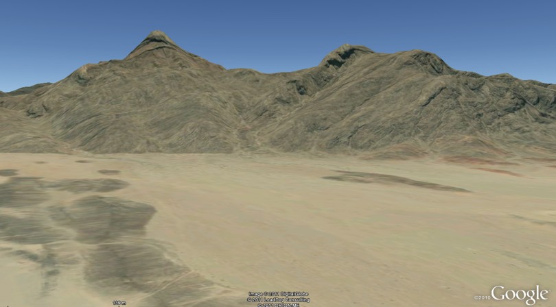
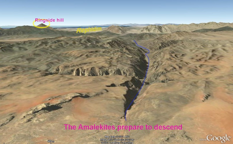
This author is quietly confident that you have now laid eyes on the rock of Horeb. It all fits. Beautifully. The Amalekite death wishWhile camping at Rephidim, the Israelites came under vicious attack at the hands of their relentless enemy, the Amalekites: Now Amalek came and fought with Israel in Rephidim. And Moses said to Joshua, "Choose us some men and go out, fight with Amalek. Tomorrow I will stand on the top of the hill with the rod of God in my hand." So Joshua did as Moses said to him, and fought with Amalek. And Moses, Aaron, and Hur went up to the top of the hill. And so it was, when Moses held up his hand, that Israel prevailed; and when he let down his hand, Amalek prevailed. So Joshua defeated Amalek and his people with the edge of the sword (Ex. 17:8-13). Ironically, the Amalekites may have arrived at almost the same time the refreshing waters reached the Israelite camp. That night Moses called his war cabinet together to plan the next day's strategy and tactics. The vast, flat, gently-sloping plain - about seven miles by ten miles - appears to have been prepared for this year, this week, this day, this hour. Its extensive, open, flat areas lent themselves to engagement by pitched battle. On the other hand, the numerous rocky outcrops could have afforded ideal cover for ambushes against any reconnoitering or fleeing enemy bands. Nobody knows the details of the encounter, but at the end of the day the Israelites proved stunningly victorious - because of God's help. That our Rephidim is the Rephidim is supported by another feature that fits the biblical account - the perfect ringside hill from which Moses could survey the scene.10 Here is a view of the hill from the battleground.
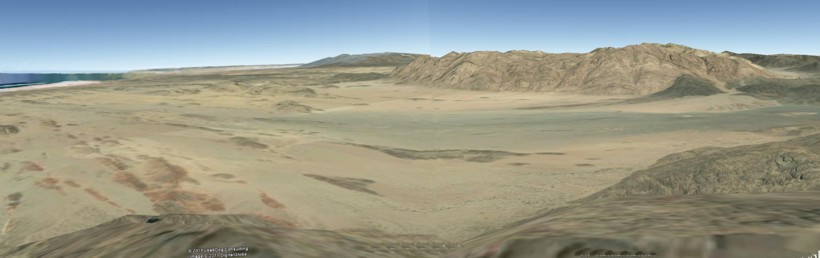
At over 3000 feet high, this hill was just the ticket. Naturally, human eyes would be incapable of seeing individuals locked in mortal combat eight miles distant, yet the record implies that Moses could see what was going on. His strategy probably involved luring the Amalekites into pitched battle around the base of the hill where he could see everything. Platoons of ambushers had no doubt been posted behind suitable outcrops all over the plain, from which they could emerge to pick off fleeing Amalekites. Here is a picture of the entire battleground as would have been seen by Moses.
The mountains on the opposite side of the plain are about seven miles away. Where did the Amalekites come from? Josephus helps us out here. He tells us that the Amalekites who attacked Israel at Rephidim "inhabited Gobolitis and Petra" (Ant., II, II, 1). The location of the famous ancient city of Petra11 is well-known as modern Jordan's most popular tourist destination. As for Gobolitis, Feldman tells us that, … this is unequivocally identical with Arabia Petrea and at the time that Josephus was writing it was actually the realm of the Nabateans and other Arab tribes. (2002, p. 167). Which territories were included in the Roman province of Arabia Petrea? The 1970 edition of Encyclopedia Britannica tells us that, "It comprised the territory of the former kingdom of the Nabateans, with the addition of some adjacent cities." (Arabia, Roman Province of ). The same encyclopedia locates the realm of the Nabateans as stretching "from the outskirts of Damascus to the eastern shore of the Red Sea and from the Sinai Peninsula far into the Arabian desert " [emphasis ours] (Nabateans). See "The Realm of the Gobolitis Amalekites" for visual explanation. These Amalekites are not one and the same as those mentioned in Numbers 13:29. Those ones lived in the south of the Promised Land. The Rephidim gang came from a vast area stretching all the way from modern Damascus in the north to Hegra in the south, and from the Arabah in the west to who knows how far east into the Arabian desert? One can even deduce the final leg of the route they took to get to Rephidim. (See "The Amalekites are coming".) Commonsense suggests they would have gathered on the high plateau12 about thirty miles directly east of our Rephidim and then made their way west down and along the large wadi to the plain of destiny. and destruction at the hands of God. We can even see what they saw from their rendezvous point on the plateau.
AltarsOur list of must-have properties did not include a couple of objects that would certainly help our case were they to be found - altars. Following the successful outcome of the battle of Rephidim, Moses built an altar there (Ex. 17:15). Later, after coming down from Mount Sinai, he built an altar "at the foot of the mountain" (Ex. 24:4). Unfortunately, to find the remains of these altars, should any still be there, would require bodies on the ground. One cannot help but wonder, however, what that square object is at 27 51 01 35 38 02, right at the base of Har Kodesh. It measures 5-6 yards across. Those faint rings around it; what are they? How many do you count? So many true Mount Sinais have been offered up over the years. So many reconstructions have been presented of the route taken by Israel between Rameses and Mount Sinai. What makes this scenario any different? You will have to be the judge of that. One final word. Being familiar with the route taken and the landscape traveled by the Israelites of old can breathe new life into one's appreciation of the second greatest event in human history. But we haven't dealt with the bigger question: What was it all about? Why did God make a covenant with Israel at Sinai? Read "Marvels and Mysteries of the Sinaitic Covenant" to see why this important question about Mount Sinai, which reflects on the glory of God, has been so often asked yet so little understood.
1 Well, this author has had no success finding its name in spite of much searching [Back] 2 Holy mountain [Back] 3 Probably located somewhere along the Arabah north of Eilat - see Genesis 20:1 [Back] 4 Coordinates: 29 01 52 34 51 11 [Back] 5 Coordinates: 28 55 27 35 10 48 [Back] 6 Coordinates: 28 27 54 35 00 39 [Back] 7 Coordinates: 28 07 03 35 04 08 [Back] 8 Coordinates: 27 50 46 35 36 41 [Back] 9 Coordinates: 27 54 23 35 41 42 [Back] 10 Coordinates: 27 57 02 35 37 20 [Back] 11 Coordinates: 30 19 28 35 28 15 [Back] 12 Coordinates: 28 03 48 35 56 00 [Back] |