 |
Somewhere, over the Red Sea: The story of the Exodus (Part One) Posted 21st August, 2011 Updated: 8th December, 2012 |
 |
|
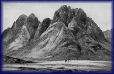
The holy mountain is shrouded in mystery, its location seemingly unknowable. Perhaps that is what makes it holy. Louis Feldman, Josephus's View of the Amalekites, Bulletin for Biblical Research, 12.2, 161-186 PILGRIMS FLOCK BY THEIR THOUSANDS EVERY YEAR to the traditionally-accepted location of Mount Sinai in the south of the Sinai Peninsula where Moses is reputed to have encountered the burning bush and, forty years later, returned with anywhere between 72,000 (Wenham 1967, p.14) and two million or so of his countrymen after escaping from Egypt. Here, at the mount known today either by its Arabic name, Jebel Musa (coordinates: 38 32 17 33 58 26), or the biblical name, Mount Sinai, pilgrims are presented with numerous opportunities to part with their cash. One writer put the reason for visiting the mountain this way: They travel to St. Catherine's Monastery, which was built by the emperor Justinian as a fortress in the sixth century C.E. at the foot of Jebel Musa, a 7,500-foot peak in the southern Sinai peninsula, and trek before dawn up the jagged granite mountainside. Near the top, they must traverse thousands of steps before they reach the summit. But most find the exertion well worth the effort, for they believe they have reached one of the places on earth where the Lord revealed himself to humankind (Kerkeslager 2000). Moses' account of the unprecedented plagues wrought upon Egypt followed by the release of many thousands, or possibly two million plus, Israelites from Egyptian bondage followed by the annihilation of the Egyptian army in the midst of the Red Sea must go down as history's most dramatic event — after the Flood. After all, no sea had ever before, and none has ever since, been sliced through by a dry-floored corridor flanked by two towering walls of water. Are millions of tourists being taken for a ride, albeit unwittingly, by their hosts and guides? Archaeologist, Bryant Wood, sums up the truth about the matter well: The location of Mt. Sinai is one of the major mysteries in Biblical research. Yohanan Aharoni has stated, "To-day the problem of identifying the route of the Exodus and Mount Sinai itself is one of extraordinary difficulty, far more than any other problem of Palestinian Biblical topography". 1 Traditionalists dicker over exactly which body of water the Israelites crossed, but they all place it somewhere along Egypt's eastern border region. They argue about the specific peak that was Sinai — at least a dozen have been suggested — but they all place it in what is today called the Sinai Peninsula. Come with an alternative if you will, but make sure it's in the Sinai Peninsula. A tremendous amount of scholarly work has been done over the years working from the premise that the traditional route is right.2 However, those who critically and open-mindedly compare traditional ideas about the Exodus, the sea crossing, and the site of the "mountain of God" with the biblical record, almost unanimously come away with a radically revised opinion. Impeccable scholarship bears no genuine fruit if based on a fairytale. Unprejudiced examination of the biblical data inevitably leads to rejection of the scenarios favored by tradition. Unfortunately, unity does not reign among the nay-sayers. A review of all the maverick scenarios reveals a complete failure to achieve consensus on all but one universally-held point - the traditional view is scandalously wrong. It is based on just that. tradition: The association of Jebel Musa with the Biblical Mt. Sinai seems to have first developed in the 3rd century AD when hermits living in caves on the mountain began to identify their mountain with the ancient holy peak. 3 That's a good basis to work from! Israel Finkelstein, noted Israeli archaeologist with a skeptical bent, remarks, In fact, the only "historical" tradition about Mt. Sinai dates from the Byzantine period, in the fourth to seventh centuries A.D., at a time when a host of holy places in southern Sinai and elsewhere were "identified." At that time the location of Mt. Sinai crystallized near St. Catherine's monastery. But this identification must be evaluated against the background of the events in the eastern provinces of the Roman world in the second to fourth centuries, as well as against the environmental aspects of the region.4 In spite of the widespread disagreement on numerous details, most students who buck the traditional view agree on two fundamental points: first, that the crossing occurred somewhere in the Gulf of Aqaba and, second, that Mount Sinai therefore must be found somewhere in north-western Saudi Arabia. This author agrees wholeheartedly with that assessment. This paper will thoroughly analyze the facts and show that they point unambiguously to the Gulf of Aqaba as the site of Israel's miraculous deliverance through the waters and to north-west Saudi Arabia as the location of the authentic Mount Sinai. It will also identify the specific peak that best matches the characteristic features possessed by the sacred mount. The question is significant for a simple reason other than the academic's quest for historical accuracy: the traditional view, particularly the version that puts the crossing of the Red Sea across a partially-dried-up, shallow, reedy lake (Great Bitter Lake or its ilk), treats the Red Sea crossing as a miracle of minor proportions. Indeed, many advocates of the traditional crossing work hard to interpret it as a natural phenomenon involving a concatenation of wind and water whose timing happened to work to the advantage of the Israelites. A straightforward reading of the Exodus account makes it obvious that Moses felt he was describing an unprecedented miracle of staggering proportions. Ditto for the numerous recitals of the event in later biblical writings. True, a crossing of the Gulf of Suez would take a lot more power than a Bitter Lake crossing, but a comparison of the depth of the Gulf of Suez where the crossing is touted to have occurred (twenty feet for one site and about 65 feet for another) with the maximum depth in the Gulf of Aqaba where a crossing logically would have occurred (2500-2600 feet) shows that an Aqaba crossing redounds far more to the glory of God. At stake is the degree of glory attributable to God. Few people are willing to credit such power to God that He could create walls of water towering thousands of feet high. Twenty feet, O.K., 65 feet, possibly, but certainly not thousands of feet. That's where they are wrong. Josephus5 informs us that in addition to 600 chariots, the Egyptian army consisted of fifty thousand horsemen and two hundred thousand footmen (Ant., II, XV, 3). How could that number possibly have perished in a few meters of water, or in a reedy lagoon? Ridiculous. Everybody knows, of course, that the entire account is ridiculed by skeptics as so much humbug. Many people get all hung up on logistical problems, some real and some contrived, which they claim whiteant the entire Exodus account, dubbing the biblical account as (as described by one person), " hilarious and impossible". They do not understand the power of God. To properly assess the realities of the Exodus one must remember that this divine project involved one of history's mightiest series of miracles. Tremendous disasters struck Egypt, water was supplied from rocks, the sea was riven asunder, quail rained down from heaven, manna covered the ground in the morning, shoes didn't wear out and feet did not swell, a pillar of cloud and fire accompanied them; God had prepared for this event before history began. In short, one does not have to prove that everything was done in accordance with normal standards - not for those who believe in God. They also forget a fundamental truth one must remember in reading Moses' writings: they are the truth, nothing but the truth, but are far from the whole truth. Endless details are left out which, were they included, would answer most objections. Many play the archaeological card, demanding that the lack of discovered artifacts of things like lost jewelry and of skeletal remains proves it never happened. Specifically, nothing has been found around the traditional sites of Mount Sinai and Kadesh Barnea where the Israelites spent one year and twenty or more years respectively. Archaeologists argue that even desert nomads left physical remains of their presence; the Israelites must have done so, too. But none has been found. Well, what can one expect when one searches in the wrong place?! ApproachThe biblical account of the Exodus presents a large amount of data; determining how to use that data to reconstruct the most likely route of the Exodus, the most likely crossing site, and the most likely location for Mount Sinai is a daunting prospect. Which bits of information provide the strongest leads and which clues should be moved to the bottom of the pile? How does one arrange the material? The approach that seems to this author to provide the best hope of a successful outcome is to determine, first, the weakest line of evidence and remove it from the equation and then to consider what constitutes the most robust data, and from which we can rough out a general route. Then we will look at and reject objections raised by traditionalists to the Gulf of Aqaba crossing and Sinai-in-Midian positions as well as giving good reasons for rejecting traditional ideas themselves. Having done that, we will return and consider the mass of other data to help refine the details. Every attempt is made in this presentation to reason logically. All too often, clarity of thought is sacrificed on the altar of. well. read "Logic and the route of the Exodus" to find out. Beware the toponymsConsider what not to consider - place names. The account is loaded with them: Then the children of Israel moved from Rameses and camped at Succoth. They departed from Succoth and camped at Etham, which is on the edge of the wilderness. They moved from Etham and turned back to Pi Hahiroth, which is east of Baal Zephon; and they camped near Migdol. They departed from before Hahiroth and passed through the midst of the sea into the wilderness, went three days' journey in the Wilderness of Etham, and camped at Marah. They moved from Marah and came to Elim. At Elim were twelve springs of water and seventy palm trees; so they camped there. They moved from Elim and camped by the Red Sea. They moved from the Red Sea and camped in the Wilderness of Sin. They journeyed from the Wilderness of Sin and camped at Dophkah. They departed from Dophkah and camped at Alush. They moved from Alush and camped at Rephidim, where there was no water for the people to drink. They departed from Rephidim and camped in the Wilderness of Sinai (Num. 33:5-15). After leaving Egypt, the Israelites camped at three locations (Succoth, Etham, near Migdol), then passed through the Red Sea. After crossing the sea they wandered for three days, then camped at seven places (Marah, Elim, by the Red Sea, Wilderness of Sin, Dophkah, Alush, Rephidim) before finally reaching Mount Sinai. Any attempts to follow the trail based on the names of campsites are doomed to failure for a simple reason; nobody knows where they are. Guesswork has been the guiding criterion. One writer puts the problem this way: And we have no idea where these sites are. They simply cannot be located on the ground with any confidence. That is why we have so many proposed routes for the Israelites' wilderness wandering. (Beit-Arieh 1988). Noted Israeli archaeologist, Israel Finkelstein, has this to say about the camping sites: The Bible refers to numerous place-names - toponyms is the scholars' word - on the route of the Exodus. Of all these toponyms mentioned in connection with the Israelites' desert wanderings only two can be securely identified - Kadesh-Barnea (Ein el-Qudeirat in the eastern part of north Sinai) and Ezion-Geber (Tell el-Kheleifeh near present-day Eilat). A few other places - Pi-hahiroth, Baal-zephon and Migdol. may be located in the northeastern corner of the ancient Nile Delta (present-day northwestern Sinai). However, of the other numerous toponyms, none can be located. From the Bible itself, there is absolutely no way to determine in what part of the southern deserts extending from the Negev to the southern tip of Sinai these sites are located (1988). We need to note that, contra Finkelstein, the location of Kadesh-Barnea has not been "securely identified" at all. He is allowing his own prejudices and biases to lead him to make that assertion. The same applies to Pi-Hahiroth, Baal-zephon and Migdol. In sum, of the places listed above, Rameses alone can be pinpointed with any degree of confidence at all! After that, every location is up for grabs. Readers are advised to take no notice of attempts to trace the route based on attempts to locate these places by the alleged meaning of the toponyms; they are about as useful as an ashtray on a motorbike. As an example, consider the crossing point, Pi Hahiroth (Ex. 14:2). One author says this: The meaning of the Hebrew word Pihahiroth is broken down as follows: 'Pi' means 'mouth of' or can mean 'to flow out'. 'ha' means 'the'. 'hiroth' the meaning is not clear. It possibly comes from the Akkadian word 'hir-i-tu' meaning 'canal' or 'channel', it doesn't appear in any other bible accounts (apart from those of the Red Sea crossing). Therefore the whole word means 'mouth of the channel' or the channel estuary or the gulf estuary. Plainly this is the estuary of the gulf of Aqaba.6 He sees a clear description of the Straits of Tiran near the entry into the Gulf of Aqaba. Others differ. A more scholarly figure, Gordon Franz, thinks it means this: Scholars have debated the meaning of Pi Hahiroth but the consensus seems to be that it is a Hebraized form of Akkadian origin meaning "mouth of the canal". If that is the case, what canal is being referred to? I would like to propose that there was a canal from the Bitter Lakes to the Gulf of Suez, or at least the remnants of a canal that was started and abandoned by the time of the Exodus, but the toponym was still known.7 Ron Wyatt, controversial promoter of a Midianite location for Mount Sinai, has a completely different identification based on the meaning of the name: Pi-Hahiroth means, mouth of the hole, which we would apply to the mouth of the canyon [leading from the mountains onto the beach]. 8 The eye of faith can see anything in names. The exercise is too subjective to be of much value. Indeed, logical deduction may supply the general whereabouts of some of these places, but we cannot use their names as clues. Consider now the two most compelling pieces of information that can be brought to bear on the task of tracing the Israelites' footsteps. The identity of the Red SeaFew topics betray more clearly the anti-supernatural prejudice of many writers and the subsequent weasel logic they bring to bear on the question of which body of water Moses was talking about in Exodus 15:4: Pharaoh's chariots and his army He has cast into the sea; his chosen captains also are drowned in the Red Sea. Despite all the hyperbole and spin, we can identify the "real" Red Sea with considerable confidence. That is, if we accept the biblical data. True, the Hebrew term, Yam Suf , does not literally mean "Red Sea". "Yam" is the normal word for Sea, while "suf" appears to have a number of different possible meanings. However - and this is a critical point - when used in the Bible, the term unequivocally can refer to what we know as the Gulf of Aqaba. One verse alone suggests that it may also refer to the Gulf of Suez or some other major body of water to the east of the Egyptian delta. Consider, first, this passage: And the Lord turned a very strong west wind, which took the locusts away and blew them into the Red Sea [Yam Suf]. There remained not one locust in all the territory of Egypt (Ex. 10:19). This passage describes how God brought an end to the locust plague He had inflicted on Egypt. The Gulf of Suez and other shallow lakes nearby are considerably closer to the main population centre of Egypt (about eighty miles) than is the Gulf of Aqaba (about 210 miles). Thus this text shows that the term "Yam Suf" might include the Gulf of Suez or some other body of water. On the other hand, one cannot rule out the possibility that the locusts were indeed blown over 200 miles. The Gulf of Suez lies more south of the Egyptian delta than it lies east, while the Gulf of Aqaba is much closer to an eastern position and thus more likely to become a watery grave for locusts sailing on a strong west wind. However, this verse makes it impossible to assert that the Yam Suf consists of the Gulf of Aqaba and the Gulf of Aqaba alone. It may include the Gulf of Suez or, as it stands, some other large body of water lying east of the delta. Let's make this point clear: Yam Suf may include a body or bodies of water near Egypt, but it definitely was used for the Gulf of Aqaba. A crossing of the Gulf of Suez would demonstrate considerable power, and should not be rejected on the basis of the puniness of the miracle. Other factors to be introduced later give solid grounds for rejecting the Gulf of Suez and any other bodies of water as the crossing site, leaving the Gulf of Aqaba as the sole contender. As for a Gulf of Aqaba identification with the Yam Suf we can entertain no doubts. Consider 1 Kings 9:26: King Solomon also built a fleet of ships at Ezion Geber, which is near Elath on the shore of the Red Sea [Yam Suf], in the land of Edom. Not a single scholar doubts that here Yam Suf is one and the same as the Gulf of Aqaba. Other verses that corroborate the equation between Yam Suf and the Gulf of Aqaba include Exodus 23:31, Numbers 21:4, 1 Kings 22:48, and Jeremiah 49:21. Based on this vital evidence, one can conclude that the corridor of deliverance most likely crossed the Gulf of Aqaba. Yes, it's that simple. Many reject both a Gulf of Aqaba and Gulf of Suez crossing on the grounds that it could not have happened. without a miracle: Although Yam Suf does sometimes refer to the Red Sea, that cannot be the case for the body of water that the Israelites supposedly crossed dry-shod. The Red Sea is a very large, wide body of water. Besides, there are no reeds there.9 The reason for the objection is clear: miracles don't occur. do they? For the Holy One of Israel, though, the Exodus miracles would have been duck soup. The general location of Mount SinaiDoes it matter a hill of beans where exactly God cut the old covenant with Israel? If any group has a vested interest in determining its location, it would be the Jews. Note what the Encyclopedia Judaica has to say: There is no Jewish tradition of the geographical location of Mt. Sinai ; it seems that its exact location was obscure already in the time of the monarchy. Rabbinical literature was always more concerned with the contents and ideas of the Torah than with the question of where it was given (Mount Sinai). Indeed, the location cannot be nearly so important as the "theology". Knowing exactly where it was did not make the participating Israelites one whit more godly. They were there, they walked where nobody had ever walked before, they saw the pyrotechnical display of God's glory, but their hearts remained hardened. Identifying the location with absolute certainty will bring nobody to his knees before God. Of far greater moment than being able to identify this mountain is to recognize God's atoning kid (Lev. 16:9)! However, for those who do believe, being able to see this mountain, albeit in virtual space, in all its low-resolution glory really can make a difference. When you can literally see the route and the holy mountain, the entire account is transformed from legend to real life; God's calling of Israel as His special people takes on a whole new meaning. Nearly all theologians of nearly all Christian persuasions push the view that God's calling of Israel from Egypt has no relevance during the "Christian dispensation". As the magnitude of the Exodus dawns on you with ever-increasing brightness, the more clearly you can see how preposterous is the orthodox view. ( For a helpful discussion of the relevance of this topic, see Styx, "The Route of the Exodus, the Location of Mount Sinai, and Related Topics". One can download either an .rtf file or a .pdf file at www.wlsessays.net/node/1874 ) Though we will come back later to consider the alternatives presented in more detail, here we will cut to the quick and establish where this article is headed. We don't want any confusion on this score. Here, now, is vital information for revealing the general whereabouts of Mount Sinai, the place where God made the punitive old covenant with Israel after they had fled from Egypt. God said to Moses while he was tending sheep at Mount Sinai, "Come now, therefore, and I will send you to Pharaoh that you may bring My people, the children of Israel, out of Egypt." But Moses said to God, 'Who am I that I should go to Pharaoh, and that I should bring the children of Israel out of Egypt?' So He said, "I will certainly be with you. And this shall be a sign to you that I have sent you: When you have brought the people out of Egypt, you shall serve God on this mountain"(Ex. 3:10-12). God promised Moses that He would bring the entire house of Israel to this same mountain to worship Him. Where was this mountain? Although no geographical coordinates are given in this account the general locality is made abundantly clear; it was in Midian! Note the background. Exodus chapter two recounts an incident in which Moses, while living in Egypt as Pharaoh's adoptive grandson, killed an Egyptian taskmaster for beating an Israelite slave. Knowing that his life was in danger, Moses fled far from Egypt to the land of Midian (2:15) where he married the daughter of the Midianite priest, Jethro, and lived for forty years. Here he took charge of Jethro's flock. Towards the end of the forty years he ". led the flock to the back of the desert, and came to Horeb, the mountain of God" (Ex. 3:1) where the burning bush epiphany occurred. The rest, as they say, is history. Where is Midian?, you rightly ask. Consult any Bible dictionary or history text and you will find near universal agreement as to its location: on the eastern side of the Gulf of Aqaba. John Sawyer tells us, The city, and therefore the land of Midian-Madyan, can be localized exactly as it has been known under this name into modern times. It was mentioned and described by classical and Arab geographers. According to these descriptions, the land of Midian extended east of the Gulf of Aqaba. Exactly how far the land of Midian extended to the east and to the south is unclear; the borders probably varied over the course of time (1981, p. 11).10 Yes, contrary to all that you have likely been taught, the "mountain of God" is to be found in the north-west of modern-day Saudi Arabia. In all likelihood the Israelites used Wadi l-Abyad as the main route for their southerly journey towards Mount Sinai after crossing the Gulf of Aqaba. To become familiar with the terrain and the wadi,11 readers are encouraged to spend an hour or two with Google Earth. This author proposes that Mount Sinai is to be located towards the southern end of the land of Midian. Or, possibly, it lay beyond Midian's southern "border". The mount favored by most Saudi Arabia aficionados - Jebel al-Lawz - simply doesn't cut the mustard in a number of vital respects. (This view is promoted by many individuals, the most notable being Ron Wyatt, now deceased, and Bob Cornuke and Larry Williams. For a discussion of the reasons for rejecting a Jebel al-Lawz identification of Mount Sinai, see "Why not Jebel al-Lawz, then?") For those readers who may feel uncomfortable bucking tradition, please realize that more and more serious students of Bible history are doing just that. Consider this statement by Allen Kerkeslager in the popular archaeology magazine Bible Review: The Jebel Musa location for Mt. Sinai is by no means universally accepted. Harvard University professor emeritus Frank Moore Cross, championing a strand of earlier scholarship, suggested that the real Mt. Sinai is not the mountain that overlooks St. Catherine's. According to Cross and others, it's not even in the Sinai peninsula - they believe Mt. Sinai was in ancient Midian, modern northwestern Saudi Arabia and southern Jordan ( April, 2000). Although Frank Moore Cross's reasons for plumping for a Midianite connection spring from literary rather than historical considerations (he does not appear to believe in a miraculous crossing), his opinion against a Sinai connection lends credibility to the thesis being presented here. Don't dilly dally on the wayExodus buffs often ignore a piece of helpful evidence in the search for Mount Sinai - Elijah's pilgrimage to the holy mountain. When Wicked Queen Jezebel issued a death warrant against him, Elijah, depressed and discouraged, fled to Beersheba where he fell into a deep sleep. Upon awaking, he found a hearty meal waiting for him. An angel then told him he was about to go on a long journey, upon which Elijah. . arose, and ate and drank; and he went in the strength of that food forty days and forty nights as far as Horeb, the mountain of God (1 Kin. 19:8). Assuming that Elijah's strength was miraculously sustained for the entire period, we can deduce that Mount Sinai was a considerable distance away. ( Such an assumption is surely a safe one when you consider the alternative. Without a miracle, Elijah would almost certainly have died trying to walk hundreds of miles on an empty tank! He would have made easy pickings for lions and striped hyenas.) Taking out six or seven days for Sabbath rest, he had about 34 days for walking. Now, if he walked twenty miles per day - which he could have done easily - he would have travelled 680 miles. At ten miles per day - an insult to his manhood - 340 miles. A problem immediately arises; at even the insult pace, he could have walked way, way past the very southern tip of the Sinai Peninsula (234 miles) and considerably further than any of the proposed "true Sinais" if he took the shortest route. A simple solution is to assume he walked from Beersheba to Jericho, the point at which the Israelites' wanderings came to an end, and then "made pilgrimage" by retracing the path taken by the Israelites to that point from Mount Sinai. Such a path, following the traditional ideas about Israel's wanderings between Sinai and Jericho, would have taken him on a journey of about 330 miles to reach Jebel Musa, a tad under the insulting pace of ten miles per day. To get to Har Karkom - a north Sinai candidate for Mount Sinai - he would have walked a little over eight miles per day. The point is, the Elijah pilgrimage provides strong support for the most distant candidate for Mt Sinai that fits all the other important criteria. "Our Sinai", located in north-west Saudi Arabia, would have taken him on a 490 mile pilgrimage, an average of 14.5 miles per day. Jebel al-Lawz , the popular Saudi Arabian candidate, would have reduced his total trip by about sixty miles, making his average daily walk about 12.7 miles. The minimum distance we may expect Elijah to have walked must be set against the maximum distance the Israelites could have travelled after crossing the sea. For reasons we will relate later, we can deduce that the crossing occurred about the 22nd day after leaving Egypt. The total time taken to get from Rameses to Mount Sinai is revealed in Exodus 19:1: In the third month after the children of Israel had gone out of the land of Egypt, on the same day, they came to the Wilderness of Sinai. The phrase "on the same day", meaning literally "in that/this day", doesn't immediately yield its meaning to us. We will consult the experts for help: This took place on the first day of Sivan, the third month [Nissan, Iyar, Sivan] from the Exodus, which took place in Nissan (Scherman 1993, p. 401). From the departure from Egypt on the 15th Nissan to the first day of Sivan is a total of 45 days, meaning they had about 22 days to walk from their beach of deliverance to Mount Sinai. Taking time out for Sabbath rest, they had roughly 18-19 days to get to Mount Sinai. At twenty miles per day they would have covered 360 miles. But after crossing the sea, everything changed. The pressure was now completely off as flight was no longer necessary. Whereas the account of the race from Rameses to the crossing point mentions three encampments (Succoth, Etham, and Migdol - most nights they would have slept rough), seven campsites are listed between the beach and Mount Sinai (Numbers 33). Pitching tents suggests they stayed a couple of days at each location. On one occasion they camped by the Red Sea (Num. 33:10). Following a lifetime of beatings and a harrowing race across the desert, one would imagine they were given a few days rest and relaxation by the seaside. At Rephidim they engaged in a fierce battle with their ruthless, inveterate enemies, the Amalekites (sub-tribes of Edomites) at least a day following their arrival there (Ex. 17:9). Josephus recounts that the battle occupied the entire day, and it was only "the approach of night. [that] obliged the Hebrews to desist from killing any more".12 The next day was spent stripping the enemy dead and plundering their camp. In short, the pace of progress dropped dramatically, with the average daily walk undoubtedly falling below ten miles per day. Around 100 to 150 miles would seem a likely distance for them to travel in toto. Logic suggests that the quest for the true Sinai should concentrate on the area between 100 and 150 miles south of the crossing beach head. Searching for a majestic mountain peak that meets this criterion among the mountains of the coastal chain running roughly parallel to the Red Sea leads to an unnamed peak13 situated about 125 miles south of the beach landing. Its coordinates are 27 51 35 35 44 33. Copy these coordinates and paste them in the Google Earth search box and for the first time in your life you will see what may well be the true Mount Sinai. It fits in every way. We need a way of distinguishing it from all other peaks mentioned in this article. I know: "Nameless peak, I hereby dub thee Har Kodesh."14 To reach it would have required Elijah, as mentioned above, to travel 14-15 miles per day and the Israelites to average about seven miles per day after the crossing. One other peak a little further south - Jebel Shar15 - is worth examining. Doing so, however, shows it does not meet the criteria nearly as well as Har Kodesh. And, at 6500 feet in height, Jebel Shar is dwarfed by Har Kodesh by over 800 feet. Once you have become acquainted with Har Kodesh using Google Earth you will wonder why it has so far failed to be accepted by all as the "gotta-be" true Mount Sinai. Actually, it's not surprising. First, the Midianite connection is still scorned by most and therefore not investigated. Second, Google Earth arrived on the scene only recently; nobody has had the opportunity until now to do what is being done here. Other arguments for a Midianite SinaiTwo other points are often raised by supporters of a Saudi Arabian connection. First, much is made of Paul's statement in Galatians 4:25: . for this Hagar is Mount Sinai in Arabia. The idea, of course, is that the term "Arabia" does not include the Sinai Peninsula, and so we have absolute proof that Mount Sinai is to be found somewhere east of there. The second point made is that in passages such as Deuteronomy 16:1: Observe the month of Abib, and keep the Passover to the Lord your God, for in the month of Abib the Lord your God brought you out of Egypt by night. This, and other passages, say that God led the Israelites "out of Egypt". The argument then goes on to say that the Sinai Peninsula was firmly under Egyptian control, indeed, was "part of" Egypt, and hence could not qualify as being "outside Egypt". One must, therefore, look further east, beyond the Gulf of Aqaba for the location of the true Sinai. Unfortunately, these particular arguments generate a lot more heat than light, without either side seeming able to establish its thesis as bulletproof. For example, concerning the "Arabian connection", Sparks argues that in Paul's time the term "Arabia" covered a wide area that included the Sinai Peninsula. He then adds, "Thus, Paul's remark in Galatians 4:25 is quite consistent with Mount Sinai's traditional placement on the Sinai Peninsula". Agreed. If he were to be totally honest, he would have to add, "And it's consistent with Mount Sinai's placement in ancient Midian as well". No points go to either side. This article will not deal any further with either of these points, stressing that the two points already raised provide sufficient proof that Mount Sinai is to be found east of the Gulf of Aqaba. The Exodus route in the roughThe above two pieces of critical information go together hand in glove to establish with near certainty a clear general picture: when the Israelites left Egypt they fled generally south-east across the centre of the Sinai Peninsula at breakneck speed along the well-travelled King's Highway. (More about that shortly.) Imagine the look on the faces of merchants travelling in the opposite direction. After an unexpected command to change direction, they ended up travelling along a wadi that led them to the Gulf of Aqaba at a point about a third of the way down its coast, where they became trapped between the sea on the east and Pharaoh's army and mountains on the west. After crossing the Red Sea, they journeyed eastward for a few days in mountainous wilderness before reaching the Wadi l-Abyad, a wide wadi slashing from the north to the south in Midian and forming a leg of the ancient incense route. Here they turned south and proceeded to their destination - Mount Sinai. This map provides a no-frills overview of the route from Egypt to Har Kodesh. After spending a year at the base of the mountain they headed north for the Promised Land, only to be stopped dead in their tracks at Kadesh Barnea because of rebellion in the ranks. Here they stayed for many years before setting out on the final leg of their journey leading to the Promised Land. Naturally, this view is eschewed by the majority of scholars, most of whom simply don't accept the biblical account of the Exodus, except as regards its central tenet - that ancestors of the Israelites fled from Egypt before entering the Promised Land. (Most hold that other groups infiltrated the Promised Land over the years. Jews, therefore, are seen as a race with multiple ethnic origins.) Those that take the biblical record seriously can entertain little doubt: the Red Sea of Exodus is none other than the Gulf of Aqaba and Mount Sinai is to be found in modern Saudi Arabia, not in the Sinai Peninsula. Tradition, however, maintains a tighter grip on most minds than a Scotsman on a five pound note. We will now examine important traditional ideas more closely.
1 What Do Mt. Horeb, The Mountain of God, Mt. Paran and Mt. Seir Have to Do with Mt. Sinai? [Back] 2 For a classical example of just how impressive the scholarship can be, see "The Date and Route of the Exodus" by C. De Wit [Back] 4 Raider of the Lost Mountain - An Israeli Archaeologist Looks at the Most Recent Attempt to Locate Mt. Sinai, Biblical Archaeology Review, Jul/Aug 1988, 46-50 [Back] 5 A 1st-century Romano-Jewish historian of priestly and royal ancestry who recorded Jewish history, with special emphasis on the 1st century AD and the First Jewish-Roman War which resulted in the Destruction of Jerusalem in 70 AD (Wikipedia). Much debate has centered on the trustworthiness of his factual material. [Back] 6 The Israelites Crossed the Red Sea at the Mouth of the Gulf of Aqaba [Back] 7 Where was the Red Sea Crossing? [Back] 9 Shanks 2011, p. 53 [Back] 10 The Catholic Encyclopedia article "Madianites" seems less conclusive (and less clear) on this point, seeming to suggest that in Moses' time they occupied "the country later occupied by the Moabites". In this article we will take the position enunciated by Sawyer. [Back] 11 Dry stream beds in arid environments carved out of rock and soil by periodic torrential rains; dry most of the time, except after heavy rain. Beit-Arieh comments, " Most ancient settlements were built beside these wadis, not only for the obvious reason of ease of communication with other settlements, but also because the available water resources were located mostly in the wadi beds, rather than on the high mountain uplands ". [Back] 12 Ant., III, II, 4 [Back] 13 Well, this author has had no success finding its name in spite of much searching [Back] 14 Holy mountain [Back] 15 Coordinates: 27 38 14 35 44 52 [Back] |
|
|
|
Dawn to Dusk publications |
Other printed material |
On the Web |
|
|
|
|
| Edited and expanded copies of this article, in reprint pamphlet form, can be purchased by going to the reprints order page. As well as reprints, Dawn to Dusk offers books in printed form and on CD-ROM. We mail to anywhere in the world! For more information on what is available, prices, and how to order, click the icon. |