 |
Why not Jebel al-Lawz, then? |
 |
|
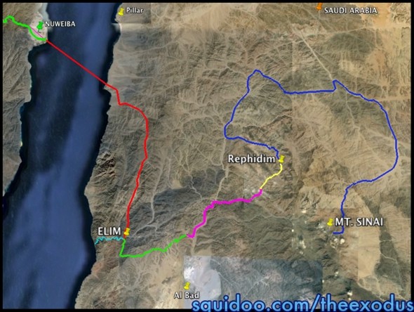
THOSE WHO ARE AWARE OF RON WYATT and his fascinating, controversial ideas and sensational claims are generally divided into two camps - avid supporters and implacable opponents. This author, remembering that one of the vital principles in seeking truth is to eschew "horns and haloes" thinking (those you support must always be right while those you oppose must always be wrong), gives Ron Wyatt credit for stirring up a rethink among Bible students about the route of the Exodus and the location of Mount Sinai. To Ron Wyatt must go kudos for illuminating the route most likely taken by the Israelites to the Red Sea and identifying the most likely crossing point. Credit must go to him for resuscitating ancient traditions that place Mount Sinai in modern Saudi Arabia. After that, it's a different matter. Let it be said right now, this author has no vested interest in disproving Wyatt's identification of Jebel al-Lawz as the true Sinai. My reason for rejecting his identification is quite simple: it doesn't add up; the scenario has fatal flaws. Let's consider them one by one. But first, you need to know where Ron Wyatt's peak is to be found. Right here we are confronted with a problem: his site doesn't give the coordinates! One wonders why not. Others have somehow tracked them down and posted them for our benefit. Here they are: 28 35 07 35 21 16. Can we be sure this is the peak he claims to be Jebel al-Lawz and the true Mount Sinai? Yes. His official website provides a photo from which we can determine that the above coordinate is correct (see Fig. 1). It's poor quality, low resolution, but it's the best we can do. B is listed on his site as the "altar with petroglyphs" (supposedly the Golden Calf altar, coordinates 28 34 52 35 23 46) while D is identified with the altar at the foot of the mount, whose coordinates are given as 28 35 04 35 22 43 by one authority. Since D is the altar at the foot of the mount, that tells you that the mount is up above it, the photograph obviously being taken by someone part way up the mount. Fig. 2 is a Google Earth shot of this peak looking from the general direction of the Golden Calf altar. Short on theaterThis argument is admittedly not the strongest, being somewhat subjective in nature, but it does weigh in against his identification. The general gist of the biblical account suggests an awesome majesty attends the true Sinai. After all, it was known at the time as "the mountain of God". It stood like a lone sentinel, head and shoulders above all it surveyed. Ron Wyatt's peak is about 400 feet lower than its neighbor a little over 1.5 miles to its south (28 33 55 35 22 09) - hardly the superlative peak that it ought to be. In addition, this peak rises a mere 2900 feet above its nearby potential campground (coordinates: 28 31 07 35 26 08), while Har Kodesh towers nearly 6700 feet above its campground. Misquoting JosephusKevin Fisher's arkdiscovery.com site, which peddles Ron wyatt's videos (doctored, it would seem), has produced a video connecting Jebel al-Lawz with Mount Sinai. It makes this statement: Josephus told us, "Mount Sinai is the highest of mountains in the region of the city of Madian". Flavius Josephus We are evidently supposed to be convicted by Josephus's statement that, since the true Sinai is the tallest peak near Madian (purported to be modern Al Bad) then Mount Sinai must be one and the same as Jebel al-Lawz, the tallest peak near Al Bad, coming in at 8,464 feet above sea level. Assuming Josephus to be correct, then surely it's a done deal. Only problem is, Josephus says no such thing. Here is what he said: Now Moses, when he had obtained the favor of Jethro. stayed there and fed his flock; but some time afterward, taking his station at the mountain called Sinai, he drove his flocks thither to feed them. Now this is the highest of all the mountains thereabout. (Ant., II, XII, 1). True, the previous chapter had mentioned that Moses had married Jethro's daughter, and suggests that he lived in the vicinity of Madian. But the point to be made is that Moses drove the flocks away from the vicinity of Madian to Mount Sinai. It is dishonest to claim that Josephus makes Mount Sinai the tallest mountain near Madian. It is the tallest peak in the vicinity of wherever Moses went to pasture the flock, which could have been in the opposite direction from Jebel al-Lawz. Whether or not Ron Wyatt misquoted Josephus on this matter I do not know. Trying to distinguish between what Ron Wyatt himself said and what others suggest he said seems a nearly hopeless task. Furthermore, Josephus says that Madian "lay upon the Red Sea" (Ant . II, XI, 1). Al Bad (coordinates: 28 28 03 35 00 48) is fourteen miles as the crow flies from the Red Sea with the Jebel al-Lawz mountains being even further away. It seems to this author that Josephus's Madian should be identified with the modern Red Sea town of Al Maqna (coordinates: 28 23 56 34 44 47) or somewhere in the vicinity, not with Al Bad. Google Earth photos from the area of Al Maqna reveal the existence of "Prophet Mousa Springs" (Fig.3). However, we would be unwise to attempt to build a case on that fact - springs and wells named after Moses are not rare throughout the Middle East. To summarize: taking Josephus at face value merely tells us that the true Sinai was the tallest peak in the vicinity of the pasture lands used by Moses to pasture Jethro's flock . Not even Jebel al-LawzHaving assured us that the true Sinai rises head and shoulders above all others, it should come as quite a shock to realize that Ron Wyatt's peak - as best one can tell from the sparse information available on this point - is not Jebel al-Lawz at all, as a study of the coordinates given above, and corroborated by the official photo on the Wyatt site, shows. (Others place his peak a little further west at 28 35 04 35 21 03, a peak that rises about thirty metres higher.) In fact, it's about 5-6 miles distant from Jebel al-Lawz. You will not find any words to that effect on Wyatt's official site, but you do on the site of his supporters, Jim and Penny Caldwell. They sell a booklet entitled, "Jebel Maqla - Mount Sinai?", with a line describing it as, "In the Jebel al Lawz Mountains of Northwest Saudi Arabia". Ron Wyatt's Mount Sinai is, in fact, Jebel Maqla, not Jebel al-Lawz. One might be inclined to be charitable if it could be shown that Josephus was speaking of a range of mountains, not a specific peak, and that Mount Sinai was just one of those peaks, but no such suggestion can be wrested from his writing. The true Jebel al-Lawz rises 8464 feet, while Jebel Maqla is 7350 feet high - about 1100 feet lower! In short, Ron Wyatt's peak is condemned by his own criteria for its identification! Perhaps Ron Wyatt considered Jebel Maqla, with the alleged altars at its base, a foothill of the "true Sinai", the "true Jebel al-Lawz", nearly six miles away. I don't know. Confusion on this point could be cleared up if someone "in the know" were to publish the precise coordinates of the cave alleged to be the one Elijah sheltered in while visiting the mount or the blackened peak supposedly created when the mountain burned furiously. If the cave is on the low peak rising directly above the "altars", one is forced to ask whether such a relatively low peak could be the "real thing". If the cave is located on Jebel al-Lawz, nearly six miles distant, one is forced to ask if the altars could properly classify as being at "the foot of the holy mountain" as required by Exodus 24:4. This author finds both scenarios completely unconvincing. By contrast, our old friend, Google Earth, shows that southeast of the rugged mountain range in which Jebel al-Lawz rises the highest lies another uplifted area containing numerous peaks. Of these, the peak which we have named Har Kodesh to distinguish it from all others, stands the tallest. This peak eminently meets all the other biblical criteria against which the true Mount Sinai must be judged. From Rock at Horeb to Sinai campgroundWyatt supporters are very confident about their identification of the Rock of Horeb with a most intriguing split rock at 28 43 41 35 13 55 (Fig. 4). Rephidim must therefore be found nearby. A couple of problems become immediately apparent. Where is the camping area large enough to house all the tents? Check the area carefully and you cannot find one. But even more problematic is trying to figure out what route the Israelites took from the vicinity of this rock to their final resting place a few miles from Jebel Maqla, about sixteen miles away in a straight line. Between this rock and the Jebel Maqla camping area lies the true Jebel al-Lawz and an expanse of rugged terrain that appears impassable to carts. No series of wadis can be found that connects the one up with the other. It would take many days to wend their way along the rabbit warren of circuitous, narrow wadis they would have had to negotiate to get from the Rock of Horeb to "Sinai", without any suitable camping areas being available along the way. As best this author can tell, no negotiable way can be found to get from this rock to Jebel Maqla without walking an absolute minimum of seventy miles in a large circling movement. (See the route proposed at "The Exodus Discovered!") Yet Scripture doesn't mention any campsites between Rephidim and Sinai. Furthermore, this route would involve retracing their steps back to Wadi l-Abyad, a maneuver that is nowhere suggested in the biblical account. In addition, adding an extra seventy miles to the total distance travelled would require more time than the scriptural record allows. The split rockBut isn't the evidence for a miraculous "water event" at the rock discovered by Jim and Penny Caldwell so compelling that one would have to be a hard-heated skeptic to reject that rock as "the one"? One must confess that reading the Caldwell's account of their split rock makes one wonder for a moment what could possibly account for its fascinating water features if not the biblical miracle. At this point we have to try to think as clearly and logically as we can. Let it be said right here that the following comments do not, logically, repudiate their rock as being "the one". The point being made here is that the evidence the Caldwells put forward as near proof of its identity should be rejected. Let's try to understand. Their report tells us that "deep channels were cut into the granite base" leading away from the rock that were obviously made by "copious amounts of flowing water". They present these deep channels as evidence of the miraculous flow of water while the Israelites were camped nearby. Hold your horses right there. At this point, every reader has to ponder a vital question. What kind of evidence would the miracle described in the Bible leave behind? We are told that God split a rock open and the water flowed profusely. We would all agree, surely, that if this rock could be found today it would bear the scars of the miraculous splitting. The Caldwell's rock is split. But what readers should understand is that thousands and thousands of split rocks can be found around the world, and no doubt in the general area. Geological processes created by God split rocks, too. Work. True, their split rock has great appeal. In all likelihood it is fairly unique - just as every human finger print is unique. Every example of split rocks that you can find will be unique. The aesthetic appeal of this rock, however, cannot be used to establish its authenticity as "the one". The vital question here is whether or not we would expect to find evidence of erosion of the bedrock as a result of the miraculously-produced water. The answer to that is a resounding "no". Unless, that is, God not only miraculously produced water but also miraculously eroded the rock. Of course He could have done so if He wished to. But would He?; that is the question. This author personally sees no reason why He would have caused a miracle of erosion. Supporters of this rock may believe that He did, but their conviction does not make it so. Remember, the Israelites remained at Rephidim for a few days at most and so, without an erosion miracle, virtually no geological evidence would have survived to tell the tale other than signs of splitting. Those committed to this split rock may retort that the water must have continued to flow for a few thousand years after the event. (One wonders why God would not have kept it flowing until our time, then.) Alright, let's accept that possibility. How deeply could channels have been incised into the bedrock in, say, 3000 years? Maybe an inch or two. Eric Small and others tell us that in their studies of erosion rates of alpine bedrock they found that, "The maximum mean bare-bedrock erosion rate from these alpine environments is 7.6 + 3.9 m My -1." Translated, that means somewhere between 3.7 and 11.5 metres per million years. Working from the maximum rate of 11.5 meters per million years would translate into an incision depth of about 1.4 inches in three thousand years! The same article does go on to say that "basin-averaged denudation rates" reach 50 meters every million years. Even at that rate the channels would be no more than seven inches deep after 3000 years. Naturally, rates of wearing depend upon the nature of the bedrock. But one vital point is that wearing of rock by running water is wrought by suspended particles banging against the rock and abrading it like sandpaper. Without such a load of suspended particles the erosion rate would drop dramatically. Perhaps one could argue that God loaded the water coming out of the rock with particles of sand to ensure that erosion occurred, but it seems more likely to this author that the water that came gushing out of the rock at Horeb was as pure as a newly-baptized convert. The nature of the circumstances that produced the deep incisions in the bedrock might make a fascinating study for geologists. The channels cannot, however, be used as evidence to estabish its authenticity as a player in the Exodus story. In sum, the split nature of the Caldwell's rock makes it a distinct candidate — along with any other split rocks — but that's as far as it goes. As much as one hates to knock a cherished belief, the Caldwell's split rock does not compel its acceptance as the one Moses struck. Sorry, but facts are facts. The last strawWe have kept the biggest, baddest problem for Ron Wyatt's Mount Sinai - the route between the Red Sea and the mount - to the last. Numbers 33 is quite straightforward in listing a camp by the Red Sea after the Elim stopover, (the place of wells and palm trees). Any scenario that fails to include a Red Sea stopover can be rejected summarily. Many people who embrace the Jebel al-Lawz identification with Mount Sinai simply ignore this vital fact. Fig. 5 shows the "standard" route presented for the journey from the beach to Jebel al-Lawz. Can you see a Red Sea stopover en route? Incidentally, this requirement proves fatal to the proposed Straits of Tiran crossing site. No sensible route can be found that takes you away from the Red Sea for a number of days and then brings you back to it again.
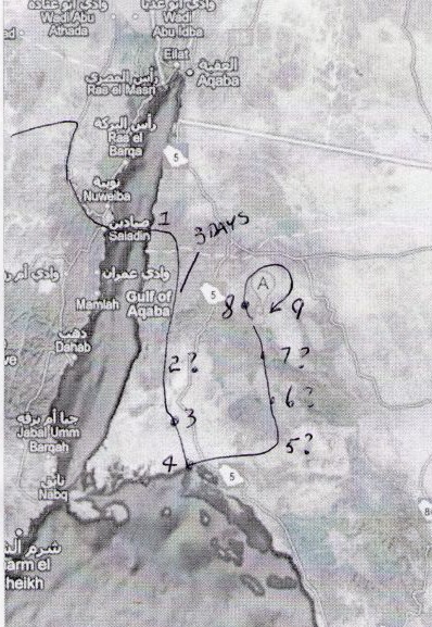
The author of "The Exodus Discovered! Egypt to Arabia" presents a route that plugs in a Red Sea campover. Only problem is that this route would prove impossible for the Israelites to have taken. At two locations they would have run into totally impassable terrain. First, the proposed route follows an ascending wadi from the arrival beach up to the mountain peaks around 28 47 26 34 55 24 then over the top of the mountains and down a descending wadi towards the proposed Elim camp at 28 34 12 34 50 08. A close examination of the terrain that they would have had to scramble over to get from the ascending wadi to the descending wadi on the other side shows that it would have been very difficult for people to negotiate and totally impassable for carts. The same comment applies to the proposed route taken from Elim to the Red Sea. It's just not doable. And even if they could have followed the proposed route they would have found nowhere to camp when they reached the coast! Please check it for yourself on Google Earth. Adding insult to injury, he then makes them double back over the exact same route all the way back to his Elim. Sorry, but that just will not do, Mr. Squidoo. Can't you hear the Israelites screaming bloody murder at having to retrace their steps over the worst terrain they had had to endure? Ron Wyatt's proposed route cannot be found on the official website. All thanks go to a friend who sent a screen shot of a route mud map taken from a Wyatt video. Please pardon the low resolution, but it's the best we could do. This proposed route can be commended for plugging in a Red Sea campover between the beach and Mount Sinai (4. on the map). Indeed, this author agrees with Ron Wyatt's general route up to that point. However, his route has to be rejected on some basic grounds.
First, consider the big picture. His route took the Israelites half way around the world to reach the village next door. It takes a huge, totally unnessary loop to get from the landing beach to their proposed split rock of Horeb (8. on the map). Instead of heading all the way south to the Red Sea, then east, then north again, they could simply have headed directly east from the Wadi l-Abyad at the appropriate point. No logical reason can be given for this proposed route. Of course, if God chose to take them that way for some unknown reason, who are we to argue. But the whole point of our exercise is to consider the evidence in order to deduce the location of Mount Sinai. The only reason one would propose that God led them on such a merry dance is a prior commitment to the Jebel al-Lawz scenario. This impractical route is evidence against a Jebel al-Lawz location for Mount Sinai. It's not only an illogical route, it's a near impossible one, as anybody with access to Google Earth can see for himself. The proposed route between 6. and 8. on the map is virtually impassable. For much of the way they would have had to scramble over steep, rocky slopes, hauling their carts and cattle up and over with sturdy ropes. Stop and think. The biblical record shows that the Israelites missed no opportunities to complain bitterly about their hard lot. It is inconceivable that they would have meekly negotiated such appalling conditions without remonstration. Yet Scripture at no time hints at bellyaching over rough terrain and the difficulties it caused. Furthermore, his route would have required the Israelites to have walked about 150-155 miles between Elim (3.) and Jebel al-Lawz. Bearing in mind that they took only fourteen days from the time they arrived at (or departed from) Elim to the time they arrived at Mount Sinai, and remembering that they spent at least a couple of days, if not more, at Rephidim, and a couple of days resting on the Sabbath, this distance would have required walking a minimum of fifteen miles per day. On the flat that would be quite possible, but considering the high, mountainous terrain involved, necessitating climbing up to at least three thousand feet on a few occasions and following a highly tortuous trail which would have added considerably to the total distance travelled, it is out of the question.
By contrast with this tortuous, circuitous, back-breaking route between beach and Rephidim, the route this author proposes between beach and his Rephidim/Har Kodesh is so much more straightforward, pleasant, and easy. It is confronted by no major topographical obstacles. Once the initial gentle climb, with an average incline of only 2.3 degrees, has been made between the landing beach and the Wadi l-Abyad, it's downhill almost all the way. The author derives no pleasure whatever from pulling the rug out from under the alleged Jebel al-Lawz identification with Mount Sinai. But facts are facts. Jebel al-Lawz can be eliminated as a serious contender in the Sinai stakes. Indeed, evidence abounds that one cannot believe much at all of what Ron Wyatt has apparently claimed over the years (see "Special Report: Amazing 'Ark' Expose" for example). As a result, one must be very cautious about taking any of his apparent finds as gospel truth. Finally, there is the archaeological evidence that Ron Wyatt found around his peak. As much as the author disagrees with Gordon Franz on a number of matters, he provides some fairly convincing rebuttals of this archaeological evidence. You will need to scroll through until you reach the section "Misunderstanding the Archaeological Evidence".
|
|
|
|
Dawn to Dusk publications |
Other printed material |
On the Web |
|
|
|
|
| Edited and expanded copies of this article, in reprint pamphlet form, can be purchased by going to the reprints order page. As well as reprints, Dawn to Dusk offers books in printed form and on CD-ROM. We mail to anywhere in the world! For more information on what is available, prices, and how to order, click the icon. |